
There are six peaks named Grizzly in Colorado, and
this one, being the second highest, is often called Grizzly Peak "B".
(The highest is a former 14'er on the Continental Divide S of Independence
Pass that was demoted by then new USGS surverys in the 1950s and '60s,
and is now a few feet short, making it the highest 13'er.) Grizzly Peak
B constitutes the postcard scenery to the N of the Purgatory/Durango
Ski Area, at the head of Cascade Creek, which comes into Highway 550
at a switchback a few miles S of Coal Bank Pass. It constitutes some
of the high ground SE of Lizard Head Pass dividing the Animas and upper
Dolores river basins.
GPS location: 37°45¼'N, 107°51.7'W; 13,738 feet altitude.
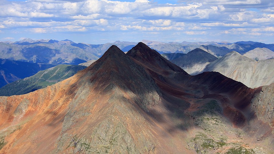
The mountain in the distance almost in line with the higher of Rolling Mountain's twin summits -- itself 2.1 miles distant to the ENE -- is Half Peak (aka "Three-Corner Table"), almost 23 miles away. At left are the 14'ers Sunshine (right - 26½ mi, in shadow) and Redcloud (left - 27¼ mi, in the sun). At furthest right, in shadow, is "North Pole Creek Mountain" (UN 13,660 "B" - 23+ mi), while about half way between it and Half Peak is Carson Peak (in sun, 26+ miles). The reddish peak on the horizon just N (left) of "North Pole Creek Mountain" is UN 13,581 (26 1/8 mi).
The mountain just to the right of the lower, western summit of Rolling Mountain is UN 13,674. It and Half Peak form the high ground dividing Cataract Gulch and Square Gulch, which feed into Cottonwood Creek just above where it joins the Lake Fork of the Gunnison River at the ghost town of Sherman S of Sunshine. The total horizontal extent in this photo is 23°, or a quarter of a quadrant.
From my series of photos around the horizon I was able to ID almost 100 high points and peaks (96, to be exact) -- just in the stretch from the N (Mears Peak) around to almost due E. There are probably at least a few dozen more in the stretch S from there through the Grenadier and Needle ranges. Grizzly Peak B is located in the SW corner of the high San Juans, and practically the entire range is spread out before you from the W (the Mount Wilson massif) around through N and E to the SSE-S. Here's the view in this other direction.
This is just one of several really good summit photos I have from the ~90 climbs I've done. I'd post more were it not for the fear that I might become known as as "just" a summit photo photographer. I chose this one for it's combination of surreality and stark, bold, contrasty abstractness. This was taken at the end of July following the 2012-13 drought winter.
The native resolution of the original digital file is 9.6 MP. This 500+ KP version for electronic display represents a reduction in area of 19½x.
All copyrights reserved. © 2018 C. Wetherill.